Figuring Out The RUTA Puebla Metrobus System
Getting around in Puebla, Mexico can be a bit of a hassle.
If you are within walking distance of Centro Historico you can do and see many things. And if you are only staying a few days, this may be good enough for you.
But if you are staying in Puebla for weeks or months or years, its size can limit you if you want to see all it has to offer.
Taxi, Uber, and Didi are options, but things can get a little expensive depending on the distance involved. For example, a trip to the CAPU Bus Station from our Airbnb can run well over $100 MEX (>$6 USD) depending on the time of day.
So transportation costs can add up if you want to explore Puebla to its fullest.
This is where the RUTA Puebla Metrobus system comes in.
Short for Red Urbana de Transporte Articulado, the RUTA Puebla Metrobus system can really help you get around if you are willing to be flexible with your time.
Generally speaking, you can get all over the city for only $6 – $10.50 MEX per trip ($0.36 – $0.60 USD).
This is a much more affordable option and really opens up Puebla for cheap exploratory outings.
The problem is that the RUTA Puebla Metrobus system is VERY difficult to figure out, due to the lack of coherent, consolidated information.
The official RUTA Puebla Metrobus webpage does have some descriptive information (in Spanish). But sadly, there is little that explains how you actually catch a bus!
Click the above link and you’ll quickly see what I mean. It’s kind of a hot mess.
With that in mind, let us show you how we figured out the RUTA Puebla Metrobus system. Hopefully after our explanation, you’ll be able to navigate it with confidence.
A Quick Heads-Up
If you are expecting some sort of app to help you use the RUTA Puebla Metrobus system, you will be extremely disappointed.
The city of Puebla has instead decided to integrate the RUTA Puebla Metrobus routes into the Google Maps database. So if you don’t install Google Maps on your phone you will be out of luck!
An Overview of the RUTA Puebla Metrobus System
TWO classes of buses are used in the RUTA Puebla Metrobus system:
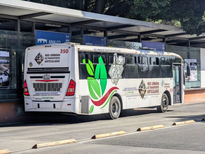
1. RUTA Troncal Buses – Service the three major bus routes (= trunks) currently in Puebla – Linea 1, Linea 2, and Linea 3.
These “trunks” form the core of the RUTA Puebla Metrobus system.
These buses use the dedicated bus lanes and raised bus platforms that can be seen throughout Puebla. Troncal buses are also usually larger and fancier.

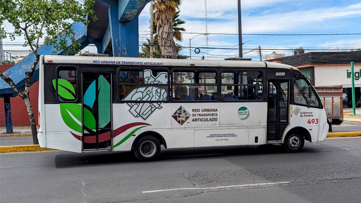
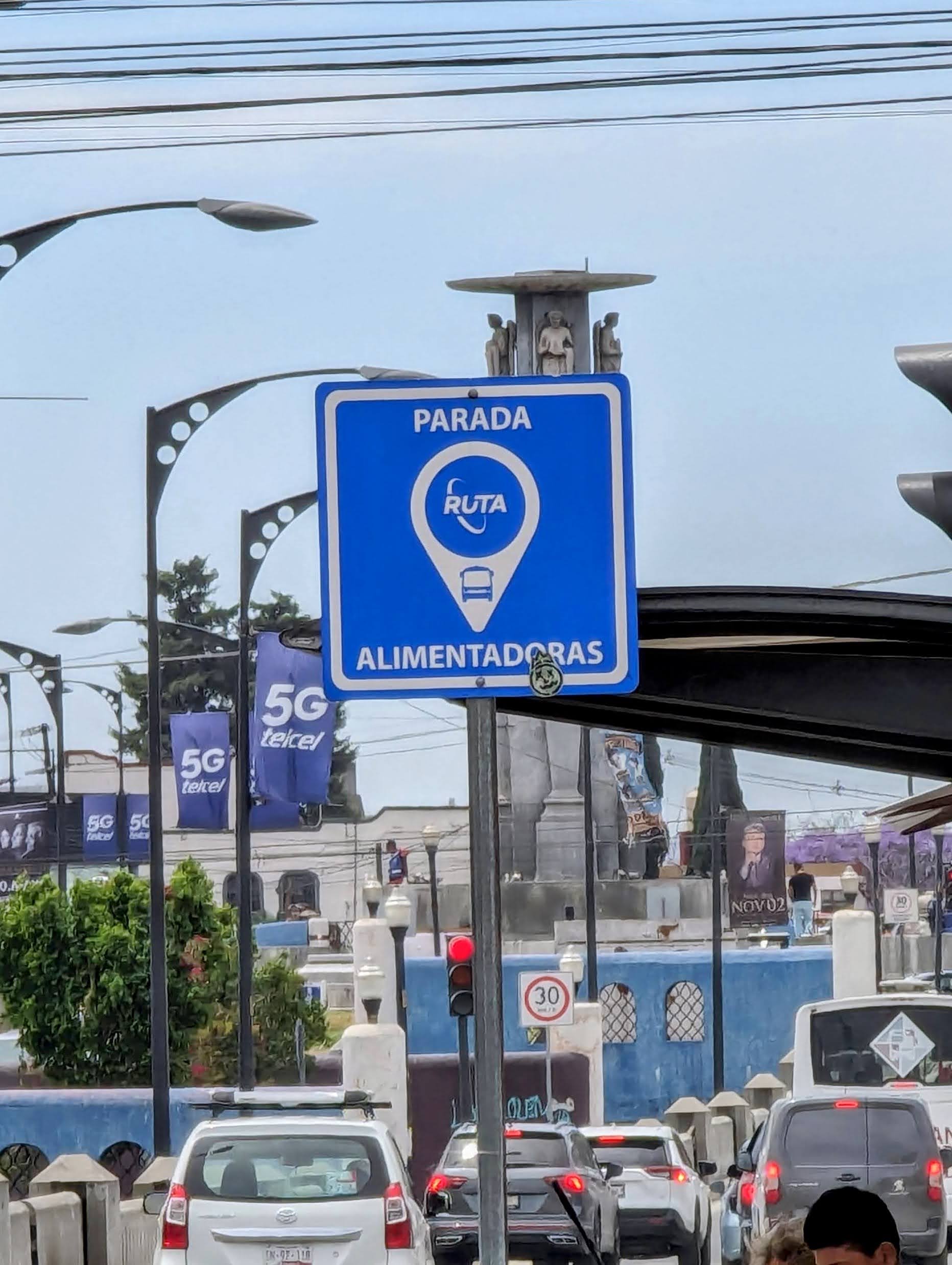
2. RUTA Alimentadora Buses – These are “feeder buses” that service routes beyond the 3 troncal lines. Alimentadora bus routes can be used on their own or can connect people to the troncal bus routes. Alimentadora buses are usually smaller than the troncal buses, but they have the same branding so they are easy to identify.
How Much Does It Cost To Take The Bus?
It depends:
- A single ride on a RUTA troncal bus (no transfer) costs $7.50 MEX.
- A single ride on a RUTA alimentadora bus (no transfer) costs $6 MEX.
- A ride where you transfer from a RUTA troncal bus line to a DIFFERENT troncal bus line (within 1 hour) costs a TOTAL of $10.50 MEX.
- A ride where you transfer from a RUTA alimentadora bus to a DIFFERENT alimentadora bus (within 1 hour) costs a TOTAL of $7.50 MEX.
- A ride where you transfer from a RUTA alimentadora bus to a RUTA troncal bus (within 1 hour) costs a TOTAL of $7.50 MEX.
- A ride where you transfer from a RUTA troncal bus to a RUTA alimentadora bus (within 1 hour) costs a TOTAL of $7.50 MEX.
Needless to say, the fares are reasonable and can take you all over the city if you time your transfers right!
But RUTA buses DO NOT TAKE CASH!
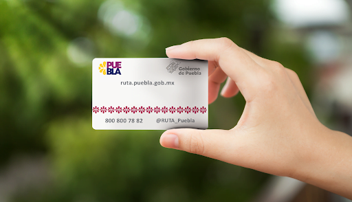
You need to buy a rechargeable RUTA card that you use to board all RUTA buses.
Is The RUTA Puebla Metrobus System Safe? Is It Comfortable?
In our experience, yes to both. With caveats.
We follow common sense safety practices and only use the bus during the day. And we make sure all of our loose belongings are safely stowed away from potential pickpockets.
If you can get a seat, the buses are quite comfortable.
But realize that if you get on at a popular station (any near Centro Historico or a shopping mall), or are traveling near rush hour, you might be in a standing room only situation.
So basically, assume the worst and be happy if things turn out better than you expect.
So How Do Use The RUTA Puebla Metrobus System?
In theory, you do the following:
- Buy a rechargeable RUTA card.
- Charge your RUTA card.
- Use your RUTA card to pay for your bus ride.
- Get off at the RUTA bus stop closest to your destination.
Sounds simple, but it’s not.
So let’s break this process down a bit further.
1. Buy A Rechargable RUTA Card
Rechargable RUTA cards can be purchased at any RUTA troncal bus stop (= Linea 1/Linea 2/Linea 3) automated teller machine (ATM).

Just press the “COMPRA” button and follow the prompts. RUTA cards cost $20 MEX – CASH ONLY.
Note that if you put more than $20 MEX into the ATM when you buy the card the difference will be used to charge it, whether you want to or not!
ATM instructions are in Spanish, but they are easy to figure out. And the security guard at each troncal RUTA station can help if needed.
2. Charge Your RUTA Card
RUTA cards are charged at the same ATMs that sell them.
You can charge your card at the same time you first purchase it by putting more than $20 MEX into the ATM.
Example: if you buy a RUTA card using a $50 MEX bill, $30 MEX will be used to charge your card.
If you already have a RUTA card, press the “RECARGA” button, insert the card into the ATM, and follow the recharging prompts.
Remember that the ATMs only accept CASH and don’t give change!
3. Use Your RUTA Card To Board Your Bus
When you enter a RUTA troncal bus station, you will be directed to pass through a turnstile with an electronic swipe pad to get to the boarding area. Swipe the card, wait for the turnstile screen to give you a green check mark, then pass through. Then when your bus arrives at the boarding area, simply get on.
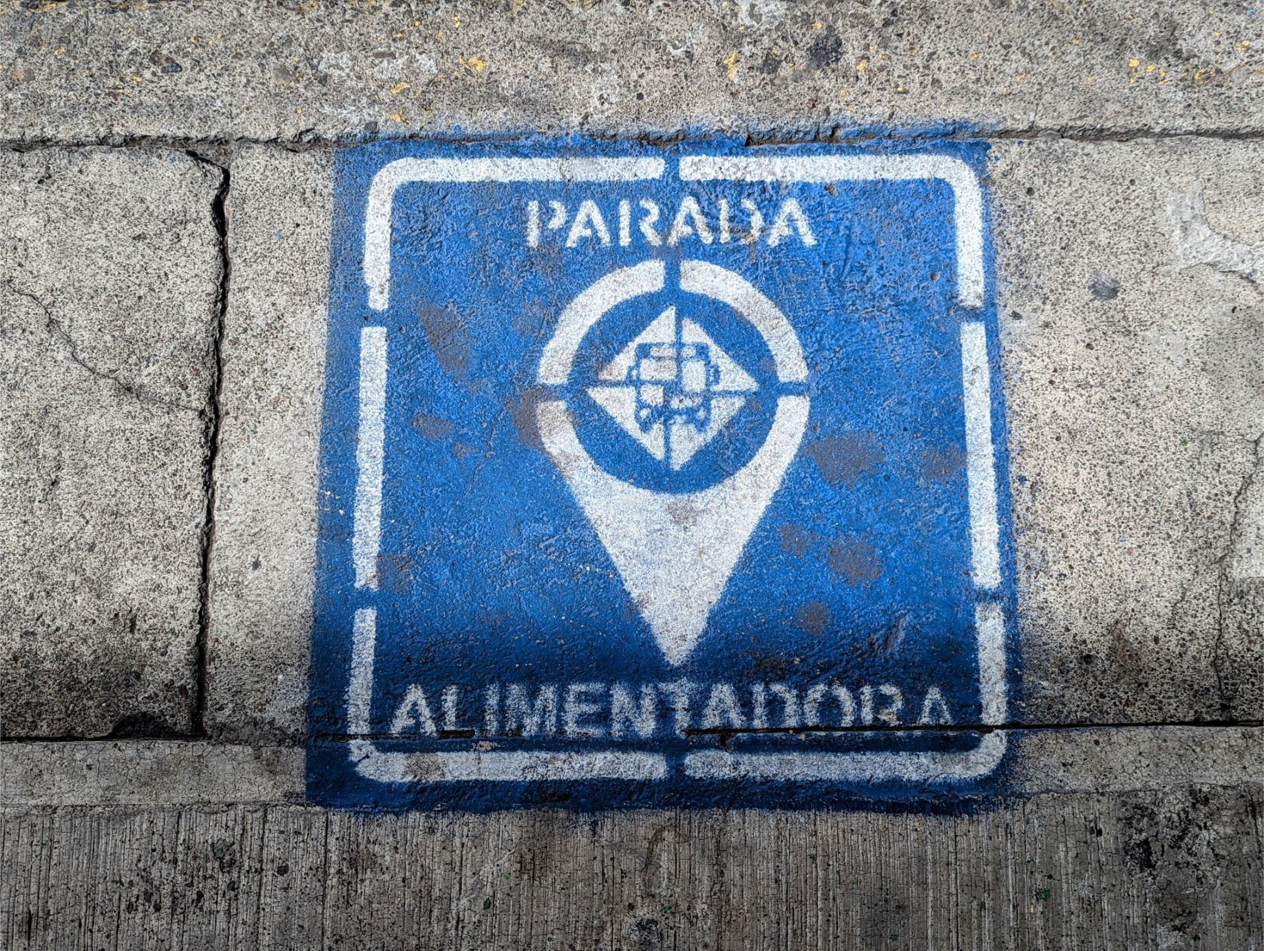
If you are boarding a RUTA alimentadora bus, you simply swipe your card at the front of the bus and get on.
4. Get Off At The RUTA Bus Stop Closest To Your Destination
Sounds easy, but the buses give no indication as to what stop they are approaching!
You will need to use Google Maps to track your progress if you don’t know where you are going so you get off at the right stop.
In advance of your ride, you should mark (i.e., save) your desired bus stops with a flag so you can monitor your approach!
Planning Your Bus Route
This is the biggest problem with the RUTA Puebla Metrobus system. There is little guidance on how to navigate the system!
And there is no smartphone app to help you determine which bus and stops are best for you.
So what do you do?
Use Google Maps.
But how you do this depends on whether you want to take a troncal or alimentadora RUTA bus.
Navigating The RUTA Troncal Bus System With Google Maps
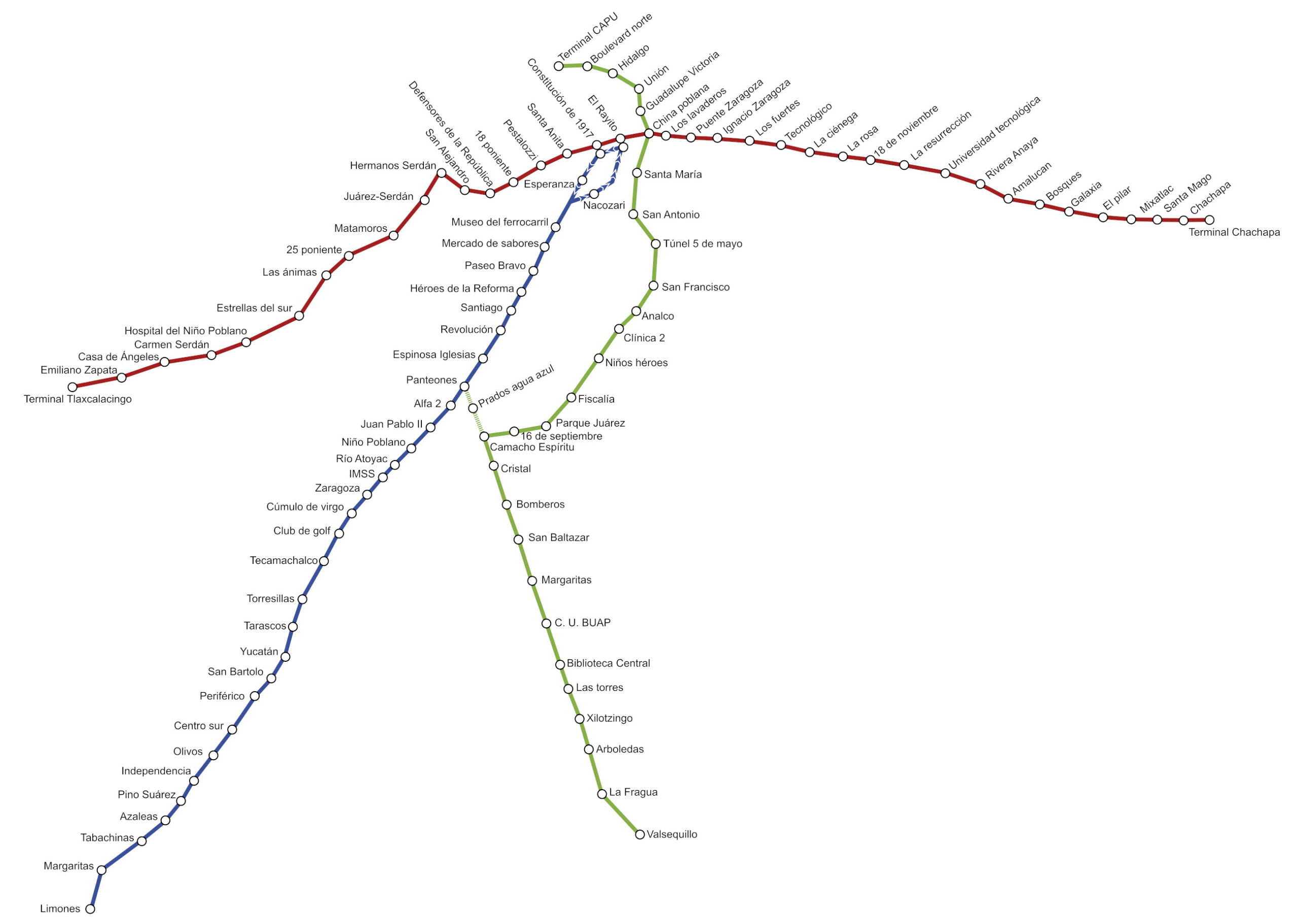
The RUTA troncal bus system is the easiest to deal with, so hopefully your current position and needed destination are serviced by it.
Here is a sexy Google Maps representation of RUTA Troncal Routes – Linea 1, Linea 2, and Linea 3:
If you’d prefer to see these RUTA troncal routes on Google Maps for use on your phone, use these links:
- ALL RUTA TRONCAL ROUTES – LINEA 1, LINEA 2, and LINEA 3
- LINEA 1 ONLY – CHACHAPA – TLAXCALANCINGO
- LINEA 2 ONLY – MARGARITAS – DIAGONAL
- LINEA 2 ONLY – LIMONES – DIAGONAL
- LINEA 3 ONLY – VALSEQUILLO-CAPU
Copy these maps to your own Google account for future reference.
With these maps active on your phone, you can now track your position relative to all the RUTA troncal routes and bus stations!
Navigating The RUTA Alimentadora Bus System With Google Maps
In a perfect world, you’ll already be close to a RUTA troncal route that takes you where you want to go.
But what if where you are (or where you need to go) isn’t near a RUTA troncal route?
You have to fall back on the feeder RUTA alimentadora bus system.
I’ll be honest, figuring this out isn’t nearly as easy as the previous method.
And it will require advance planning for it to be most effective.
But if you take the time to get to know the routes, you can get to some pretty distant places in Puebla!
There are two methods for getting the alimentadora route information you need:
Method 1 – The Google Maps Hunt-and-Peck Method
On Google Maps, RUTA alimentadora bus stations can be identified by zooming into an area you are interested in and looking for the little blue bus station symbols.

You then click on the symbol and in the information that comes up, look for routes that start with the letter “A” and then are followed by a number.
For example, A9 is a RUTA alimentadora route. So would A6 or A301. But R20 would NOT be a RUTA alimentadora route.
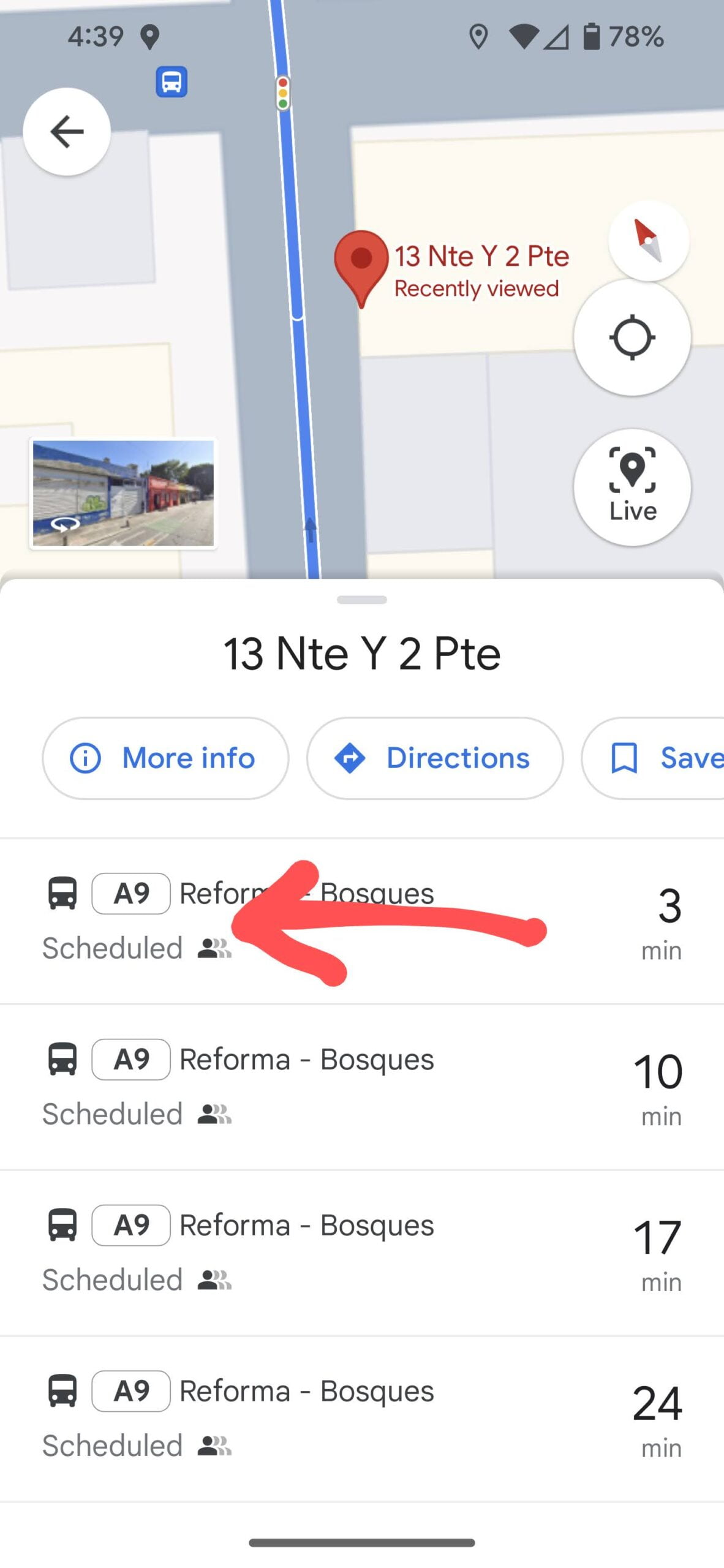
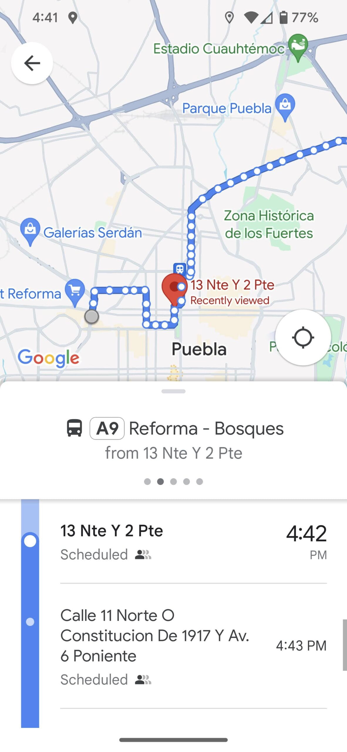
And when you click on the RUTA alimentadora route number (ex. A9), the entire route, and all of its stops, will appear.

You may need to zoom out to see the entire route.
This method is handy, but can be a bit of a pain.
Thankfully, there is another option if you’d prefer a higher altitude approach to seeing RUTA alimentadora bus routes.
Method 2 – Mine the RUTA Puebla Metrobus Website For Google Map Routes
This method can be a little tedious, but provides really good information.
First, find which RUTA troncal route your destination (or position) is closest to.
As an example, let’s assume Linea 2 is closest to our destination but is still too far out to walk. So we need to find a RUTA alimentadora route that connects our destination to Linea 2.
You then have to search the provided the provided RUTA alimentadora Google Map links (see below) to find the route that intersects with your troncal route.
Here is an example of what you will see if you click the link for Linea 2, route A23:
Nice!
You can zoom the map out to get larger scale perspective, or zoom in to see specific bus stop locations. You should then find and save those bus stops in your own Google Maps.
And with this route active on your phone, you’ll be able to track your position while on the bus.
On the map you’ll have to figure out where the RUTA troncal route connects. But that is pretty easy if you saved the Google Maps RUTA troncal route map to your phone!
Here is a clickable list of Google Maps RUTA alimentadora bus routes (accurate as of March 2024):
Linea 1 (CHACHAPA – TLAXCALANCINGO) Alimentadoras
Linea 2 (MARGARITAS – DIAGONAL and LIMONES – DIAGONAL) Alimentadoras
Linea 3 (VALSEQUILLO-CAPU) Alimentadoras
| A301 Cap. Carlos Camacho – CAPU |
|---|
| A302 Las Torres – Los Héroes |
| A303 Valsequillo – Los Héroes |
| A304 CU BUAP – Torrecillas |
| A306 Valsequillo – San Baltazar Tetela |
| A307 Valsequillo – Santo Tomás Chautla |
Make note of the routes (and bus stops) that are most useful and save them in your own Google Maps. You might be surprised where some of these routes go.
And be advised that any blank maps or inaccurate data are the fault of the RUTA Puebla Metrobus office. They are the ones that manage these maps.
Overall Impressions of the RUTA Puebla Metrobus System
The RUTA Puebla Metrobus system is useful but a MASSIVE pain to navigate! This is especially true if you need to go beyond the main RUTA troncal routes.
But with some advance planning and Google Maps tricks, you can figure out how to get to some pretty cool places without too much muss and fuss.
Hopefully, you found this post useful. If it has saved you time and trouble, feel free to buy us a coffee!
Until next time…
Thanks for reading!
If our posts have saved you time, money, or are enjoyable in some other way, BUY US A COFFEE! It helps cover the costs of our blog, keeps our blog ad-free, and motivates us to continue posting about our experiences.
And leave a comment below and subscribe to get email notifications whenever we post!
Follow Two Travel Turtles on Facebook and X.
")
")
")

")
4 thoughts on “Figuring Out The RUTA Puebla Metrobus System”
Please tell us about getting to Cacaxtla.
Ugh. Bad news on that front. Patricia drove us there as part of a longer trip to a ecotoxicology conference she was presenting at.
Sorry I don’t have much information for you!
Thanks for this it is super helpful. Is it possible to just use one card and tap twice for 1 people like you can in mex city? Just trying to avoid buying two cards for the short time we will be there.
Now that is an *excellent* question – one we wondered ourselves! Honestly, we don’t know for sure. What we do know (from the logistics involved) is that you might forfeit the discounts you get from transferring bus lines within the allotted time. And just from general observations using the system, everyone seemed to use their own personal cards, except in the case of families with youngsters, who ride for free.